
More than 2,000 search and rescue missions happen in US national parks every year. A common thread? Many trekkers had no solid plan to retreat when things went wrong.
A sunny day can collapse into a storm in minutes. A twisted ankle or a broken piece of gear can stop you cold. On exposed ridges or in deep winter, the risk isn’t just discomfort—it’s real danger.
Counting on a rescue team is a gamble. In remote places, help can be hours or days away. Your best chance is often self-rescue. That’s where a clear contingency plan becomes your most important tool.
Planning your way out isn’t about fear. It’s about respect for the wild and responsibility for your own safety. I’ve learned this on tough routes like the John Muir Trail. This guide shares the practical, tested techniques that keep people safe.
You’ll learn specific methods for route planning, gear choices, and mental readiness. These strategies work for a quick day walk or a months-long thru-hike. Emergencies don’t care about your trip length. Let’s build the confidence to handle them.
For a deeper dive into immediate response, check out our guide on what to do in a hiking.
Key Takeaways
- Unexpected weather, injuries, or gear failure can quickly turn any outing into a crisis.
- In remote or exposed terrain, self-rescue is often more reliable than waiting for professional help.
- A clear exit plan is a sign of responsible outdoor ethics, not a lack of confidence.
- Both beginner day hikers and experienced backpackers need these skills.
- Practical route planning, decision-making, and gear selection are your best defenses.
- This guide provides actionable steps you can use on your next adventure.
Recognizing the Need for a Clear Exit Strategy
In places like the Presidential Range, with its nine exposed summits, your margin for error shrinks to zero. Here, a solid plan to retreat isn’t just smart—it’s essential for survival.
Assessing environmental risks on exposed trails
A sunny day can collapse into a storm in minutes. Lightning, white-out conditions, or a simple injury are your signals to act. Terrain like steep ravines or dense forest can suddenly block your best way out.
Understanding local terrain and weather conditions
Local knowledge helps, but complacency is dangerous. Even experienced people need a structured plan to make objective choices under stress.
Before you go, study topographic maps. Note elevation profiles and natural barriers like cliffs. Mountain weather creates unique risks—prevailing winds and afternoon thunderstorms move fast.
Honestly assess your group’s fitness and skills. This self-check determines if the terrain ahead demands a detailed plan.
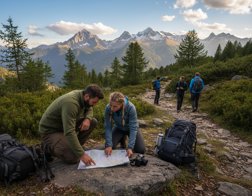
Mapping and Planning Emergency Routes
The time to find your emergency exit is at your kitchen table, not in a whiteout on the mountain. A solid plan involves more than just your main path.
You must identify primary and alternate escape routes before you go. Look for trails that get you to safety directly.
They should offer protection from weather and be easy to follow even in fog. Always avoid steep cliffs and known avalanche zones.
Selecting safe trails and landmarks
Use a topographic map or a tool like CalTopo. Mark your potential escape routes clearly. Note key junctions and estimate the distance and time to reach a road or shelter.
For example, in New Hampshire’s Presidential Range, the Valley Way Trail is a top choice. It drops into trees quickly and leads straight to a trailhead.
The Jewell Trail is another great route. It’s easy to follow and ends at a parking lot with reliable road access.
Identifying accessible road links and refuges
Your escape route must end at a place that helps you. A staffed hut like Gray Knob cabin provides shelter and a radio. The Cog Railroad station offers year-round access.
Know if the road at the end of your trail is plowed in winter. Share this detailed plan, including your decision points, with a friend at home. Mark these routes on your phone’s map, but always carry a paper copy too.
This level of preparation is a core part of any essential hiking tips for beginners list. It builds real confidence.
Mastering Hiking Exit Strategies for Hike Safety
Effective wilderness travel requires embedding escape options into your journey’s very fabric. A great plan gives you multiple paths, clear triggers, and objective rules. Your goal is simple execution when stress hits.
Evaluating multiple escape paths in critical moments
Identify specific decision points on your map. These are trail junctions or landmarks. You pause here to compare real conditions against your pre-set criteria.
Set objective rules for each point. Use wind speed, visibility distance, or group energy levels. This removes guesswork from a tense moment.
When you arrive, run a quick check. Assess the current scene. Compare it to your rules. Calculate the time to the next safe zone.
In a group without a clear leader, facilitate a quick consensus. Do not let social pressure override safety. Pre-committing to your rules helps defeat “summit fever.”
Practice this evaluation in your mind during calm stretches on the trail. Visualize the process at each decision point. This mental rehearsal makes the real task feel familiar.
Treat your exit plan as a core part of the adventure, not a separate procedure. This mindset builds true confidence for when things change.
Navigating Weather and Terrain Challenges
When fog swallows the trail and wind bites at your skin, your pre-planned escape route becomes your only reliable guide. Above treeline, rock cairns marking the path blend into the boulder-strewn landscape during white-outs. Trails that were clear just hours ago can vanish under fresh snow.

Preparing for icy trails, white-out conditions, and avalanche risks
On Mt. Washington, average winds hit 40-45 mph from January through March. Frostbite becomes a real concern for exposed skin. When visibility drops below 50 feet, you must stop forward progress.
Navigate using your compass and pre-memorized bearings. Avalanche danger lurks on the leeward side of ridges where wind loads snow. Slopes between 35-45 degrees pose the highest risk, but slides occur on steeper terrain too.
Watch for terrain traps like gullies. Deep snow zones require exhausting trail-breaking that can be impossible alone. I’ve learned to recognize when ice conditions make a route too dangerous for my skill level.
Adjusting plans for sudden storms and exposure
If lightning starts above treeline, descend immediately regardless of summit proximity. Your body loses heat fast when exhausted, accelerating hypothermia. Wind chill at 40+ mph speeds makes every minute count.
During Hurricane Hilary, even California’s Sierra Nevada faced severe weather. This shows why monitoring storms with satellite communication is wise. Dense forest provides crucial wind protection when you need to retreat.
Have clear rules: when certain conditions hit, activate your plan without debate. This practical approach has kept me safe on many challenging days in the mountains.
Preparing Essential Gear and Communication Tools
Your gear choices can mean the difference between a safe retreat and a dangerous situation. The right equipment enables a quick, self-sufficient evacuation. Missing items can trap you.
Choosing a reliable med kit and satellite phone options
Build a medical kit for problems you hope to avoid. Include Imodium for food poisoning and an ACE bandage for joint support. Add blister care and any personal prescription meds.
For communication, a satellite device is key. I prefer an unlimited plan. It lets you send updates freely during a multi-day incident.
Cell service often disappears when you need it most.
Optimizing pack weight with water filtration and lightweight supplies
Every ounce matters on a long trek. A two-ounce Sawyer Squeeze filter is a game-changer. It lets you drink from streams safely, saving over five pounds of carried water.
Choose multi-use items to lighten your load. A headlamp provides light and can signal for help. An emergency bivvy bag offers shelter and warmth.
Fuel your body with simple sugars for quick energy. Jellybeans or caffeinated gels can power a tough climb. They help you finish the activity strong.
| Item | Primary Purpose | Weight Tip |
|---|---|---|
| Sawyer Squeeze Filter | Safe water access | Replaces heavy bottled water |
| Satellite Messenger | Emergency contact | Unlimited plan for constant updates |
| ACE Bandage | Joint stabilization | Light, multi-use for sprains |
| Simple Sugar Snacks | Quick energy boost | High calorie, low weight |
| Headlamp with Extra Batteries | After-dark navigation | Essential for unexpected delays |
These investments seem like extra weight on a calm day. In a crisis, they become priceless. They give you the tools to handle the unexpected and get the rest you need.
Implementing On-Trail Decision Points
Marking specific spots on your map where you promise to stop and think is a powerful safety habit. These decision points are pre-set locations. You pause there to check conditions against your written rules.
Setting clear decision markers during the hike
Choose spots like trail junctions or treeline boundaries. Time-based markers work too, like three hours before dark.
Set objective criteria for each point. For example, “If wind exceeds 40 mph, we descend via Jewell Trail.” This removes emotional bias when you’re tired or tempted to push on.
Your pre-determined rules make the choice clear, even if you’re cold.
Coordinating with fellow hikers in group scenarios
Before the trip, agree on who makes the final call. For peer groups, a simple vote works. Ensure everyone understands the plan.
At each point, do a quick check. Reference your criteria, discuss briefly, then act. If the group splits, set a firm meeting time and share updates.
Note your decisions in a journal. This creates valuable lessons for your next adventure.
| Decision Point Type | Example Criteria | Group Action |
|---|---|---|
| Trail Junction | If visibility | Quick vote, then head to safety. |
| Summit/Treeline | If sustained wind > 40 mph, descend. | Leader confirms, group follows. |
| Time-Based (e.g., Noon) | If not past point X by noon, turn around. | Check watches, execute plan. |
This system keeps your day on track. It helps you make smart choices later in the day, not just earlier in the day. Hiking with peers becomes safer when everyone follows the same clear rules during your hike.
Insights and Lessons from Experienced Hikers
Real-world stories from the trail offer the most valuable lessons for any adventurer. I’ve learned more from listening to thru-hikers than from any guidebook. Their tested wisdom applies to your next trip, whether it’s a weekend or a months-long journey.
Reviewing case studies from renowned mountain ranges
On the John Muir Trail, a friend faced four near-quit moments over 250 miles. Rushing down Glen Pass caused a torn meniscus. Swimming in Lake Marjorie’s cold water reduced inflammation, allowing him to continue.
When Hurricane Hilary hit, he had to choose: bail out to Bishop or push big days to Vermillion Valley Resort. Pre-researched options made this decision clear. Food poisoning on Day 12 highlighted the need for a med kit with anti-diarrheal medication.
Learning from personal thru-hiking experiences
A Continental Divide Trail hiker climbed 130,000 feet over 700 miles. Techniques like churning feet for inertia and taking micro-breaks were key. Filtering water along the route saved weight and time.
Appalachian Trail veterans talk about finding purpose beyond fun. When the grind gets tough, deeper motivations keep you moving. Documenting your journey can provide that reason to finish the distance.
These experiences from iconic trails provide practical insights. They show how to manage injuries, weather, and morale on any challenging backpacking trip.
Conclusion
The most rewarding trips are those you finish, and a clear plan is your ticket to the finish line. Viewing your exit strategy as responsible preparation changes everything. It’s respect for nature’s power, not pessimism.
True safety combines map study, objective decision rules, and the right gear. It also requires mental readiness to act. This initial effort pays off quickly.
With practice, these steps become automatic. They work on a simple day hike or a multi-day backpacking trek. The techniques from the Presidential Range to the Appalachian Trail apply everywhere.
This mindset is a game-changer. A good safety net lets you attempt more ambitious routes with confidence. Start on your next outing, no matter the distance.
Experienced adventurers use these methods daily. They know expertise means seeing risks clearly. This planning protects your body and your long-term love for the activity.
It ensures you can return to the trails, season after season. You’ll complete the adventures you dream about and enjoy the rest of your journey.
