
Ever wondered if you can safely enjoy the trail alone and still feel calm and clear-headed?
I’ll walk you through one simple way to turn that idea into a real day on the trail. Start by choosing well-marked routes — national parks or familiar local trails are great first choices. These spots offer enough people nearby to ask quick questions and reduce fear.
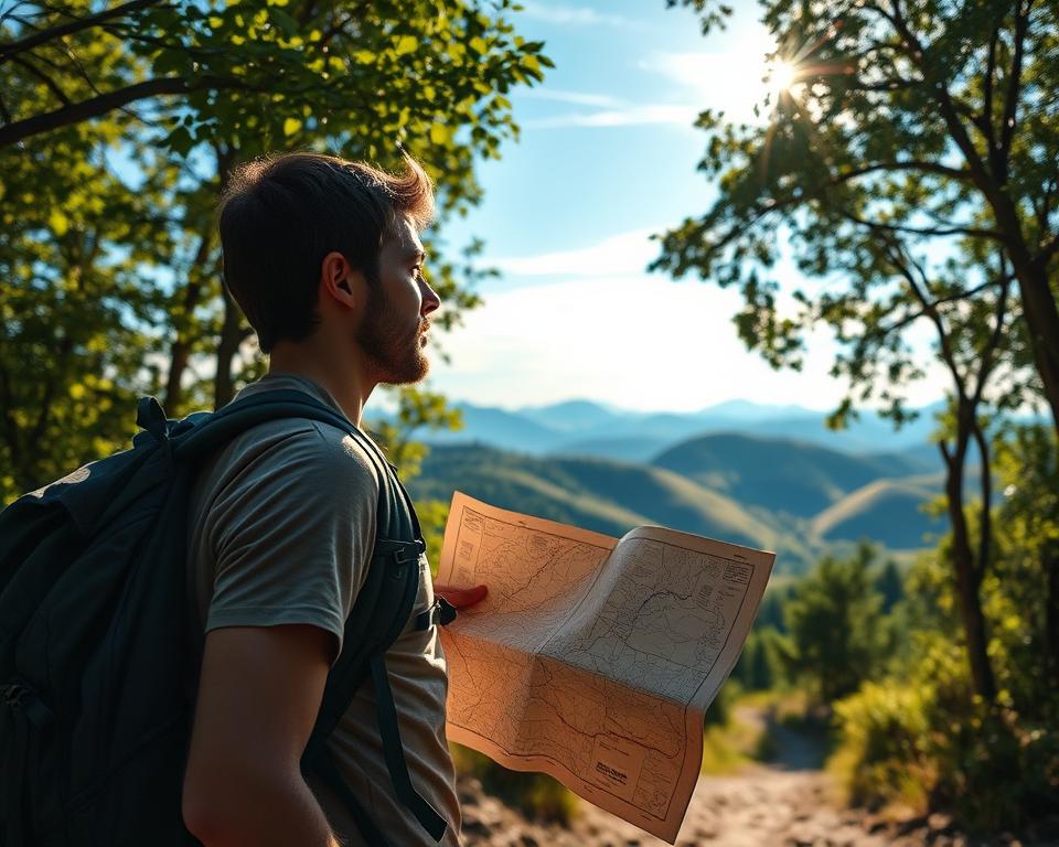
Check the forecast with apps like WeatherBug and use navigation tools such as AllTrails or Gaia GPS. Bring the Ten Essentials, carry a paper map as backup, and tell someone else your basic plan.
My goal is to help you build confidence step by step. With a short checklist and a few practical tips, your first solo hiking experience will feel like a steady win, not a test.
Key Takeaways
- Pick familiar, well-marked trails for your first day out.
- Use apps like AllTrails or Gaia GPS and keep a paper map backup.
- Check weather forecasts and carry the Ten Essentials.
- Share a simple itinerary with someone else for safety.
- Small, smart steps build lasting confidence and better experiences.
Why hike solo: benefits, mindset, and common fears
Stepping onto the path without company gives you room to slow down and notice small details. That quiet focus often leads to clarity many don’t find in daily life.
Confidence, clarity, and hiking at your own pace
Moving at your own pace is the top benefit. You can stop for photos, water, or a long view without checking with someone else. This freedom builds confidence fast.
One hiker shared a first time on Zion National Park’s Subway. It began nervously in 100°F heat and ended with steady confidence, step by step. Friendly hikers offered directions and snacks, showing how kind people on the trail often are.
Real talk: fear vs. fact when you’re hiking alone
Fear is normal, but the fact is most solo days go smoothly when you pick well-marked, well-traveled routes and use navigation tools.
- Clarity: notice plants, light, and rhythm of your walk.
- Control: choose the way at junctions and learn from each decision.
- Practice: short loops build experience and reduce worry.
| Common Fear | Fact | Small Choice |
|---|---|---|
| Getting lost | Most routes are well-marked | Carry a map and check junctions |
| Weird encounters | Hikers are often helpful | Keep a visible pack and say hello |
| Feeling unsafe | Street smarts reduce risk | Pick busy trails and short timeouts |
Planning a solo hiking trip
Choose one clear objective and work backward from your end time. Decide if you want a viewpoint, steady mileage, or a short loop. That makes the day feel simple and doable.
Define goal, time, and distance for a day hike
Pick a short, well-marked trail in your area with modest elevation for your first time. Decide your time window, then pick a distance that leaves a buffer so you don’t rush near the finish. Review the route on a map and note landmarks and turnarounds.
Create a simple step-by-step plan from home to trail to return
- When you’ll leave and where you’ll park.
- Trailhead location and planned turn time.
- Expected return time and an emergency contact with car details.
| Step | What to do | Why |
|---|---|---|
| Pre-ride | Check AllTrails or Gaia GPS, save offline map | Know route and avoid surprises |
| At trailhead | Confirm permits/parking pass and start time | Follow local rules and limit fines |
| On trail | Stick to the planned route and carry Ten Essentials | Reduce decision fatigue and handle emergency needs |
| Return | Text your contact “I’m back” and note car details | Close the loop and tighten your safety net |
Choose the right trail for your first time
Pick a trail that feels obvious to follow—clear signs, steady foot traffic, and simple turns keep your first day calm. That way you enjoy the scenery and build confidence without extra stress.
Pick well-marked, well-traveled routes below your skill ceiling
Look for gentle grades, modest elevation, and smooth tread. Familiar local loops or a classic national park route give reliable maps, frequent hikers, and clear junctions.
Why familiar routes and national park classics are smart starts
Popular routes usually have abundant info online and ranger updates. Use apps like AllTrails or Gaia GPS to check traffic, conditions, and elevation before you go.
Red flags to avoid: big river crossings, exposed ridges, confusing networks
Skip routes with major water crossings, long exposed ridgelines, or maze-like trail networks until you gain experience. These features multiply risk and slow your pace on tricky terrain.
- Choose out-and-backs or simple loops with few junctions so you always know your way back.
- Scan recent reports for closures or downed bridges that can change a short outing into a hard day.
- Factor surface type—roots and rock steps slow time, so add margin when you plan your return.
Weather first: how to read and plan around the forecast
Start your weather check with the exact trailhead, not the nearest town — that small step changes decisions fast. Look at hourly trends for the window you’ll be on the trail and spot any late-day build-up.
Use two trusted sources. WeatherBug gives live radar and a lightning map. Weather Underground shows “feels like” temps that guide layering. For mountain zones, add NOAA forecasts to see wind, cloud build-up, and precipitation timing.

Quick, practical rules for hikers
- Check the exact area and scan hourly trends for your expected day on the trail.
- You’ll want WeatherBug for lightning and radar plus Weather Underground for feels-like temps.
- In mountain or shoulder-season conditions, pack an insulating layer and a rain shell even on bluebird mornings.
If storms or strong ridge winds appear near your turnaround time, start earlier, shorten the route, or pick a lower option. Re-check radar before you drive and once at the trailhead. If thunder shows, descend from exposed ground quickly.
Maps and navigation: apps plus a paper map as backup
Good maps and simple habits make navigation quick, not stressful.
Download-and-go apps like AllTrails and Gaia GPS are my go-to for route clarity. AllTrails gives easy reviews; Gaia GPS offers strong topo layers. COTREX adds Colorado detail, and PeakVisor helps ID summits fast.
Simple steps to stay on course
- Download your route in AllTrails or Gaia GPS and save offline so your phone still shows position if service drops.
- Read recent reviews for blowdowns, water levels, or reroutes that affect how you’re hiking that day.
- Bring a small paper map backup; a tear-resistant Pocket Pal is a compact saver if batteries die.
- Snap a clear photo of the trailhead kiosk and junction boards to confirm choices while walking.
- Mark loop direction, note the key split, and glance at your position at the first junction to build steady habits.
Build your safety and communication plan
A simple, repeatable safety routine keeps your day on the trail steady and stress-free.
Tell one trusted contact your full itinerary before you leave. Include route name, start and end times, your turnaround time, car make/model/color, license plate, lot name, and county.
Make sure you set a clear “call if no contact by” time and stick to it so your family knows when to act. Add the nearest ranger station and the local sheriff’s number to your note.
Simple message template to send
- Trail: [name] — Start: [HH:MM] — Turnaround: [HH:MM] — Back by: [HH:MM]
- Car: [make, model, color, plate] — Lot: [name] — County: [county]
- Nearest ranger: [phone] — Sheriff: [phone] — Call if no contact by: [time]
PLBs and satellite messengers
You’ll want a satellite messenger like the Garmin inReach Mini for two-way texts, tracking, and SOS to 24/7 responders. Keep it on your shoulder strap for quick reach.
| Item | Why | Tip |
|---|---|---|
| Two-way satellite unit | Text off-grid and trigger SOS | Program preset messages |
| Paper map + photo | Backup if devices fail | Snap kiosk signs at the start |
| Phone on airplane mode | Save battery for calls or GPS | Turn on only to send check-ins |
Gear up: the Ten Essentials for solo hiking
A smart kit keeps you moving: choose useful items and place them where you can grab them without thinking. Pack with reachability in mind so a small problem stays small.
A quick checklist tailored to day hikes
- Navigation: app + paper map.
- Illumination: headlamp with spare batteries.
- Emergency shelter: lightweight mylar blanket.
- Extra water and food; add a filter for longer days.
- Extra clothes and sun protection for changing weather.
- Fire starter, knife/repair kit, and a compact first aid kit with blister aid.
Packing smart so your phone, map, and first aid are ready
Make sure your phone is charged and carry a small external battery with a short cable. Keep map and headlamp in the same pocket so you find them fast when light fades.
| Item | Why | Tip |
|---|---|---|
| Daypack with hipbelt | Comfort for miles | Use Osprey fit tools to find the right size |
| Whistle & bandana | Visibility and signaling | Attach to sternum strap |
| Blister kit | Prevents stops | Store inside first aid pouch |
These core items cover the basics for a safe day on the trail. Use these tips, refine your kit, and you’ll enjoy more confident hiking and steady solo hiking progress.
Dress for success: simple clothing and layering for changing terrain
Layering well keeps comfort steady as the terrain and weather change during your day. Start with moisture-wicking base layers and skip cotton—synthetic or merino moves sweat away so you stay dry and warm.
Begin cool; you’ll warm on the move. Add a light midlayer to match pace and slope, then peel it off when you hit a climb or sunlit ridge.
- Carry a reliable rain shell year-round (I use a Patagonia Torrentshell) to block wind and surprise showers.
- Pack extra socks so wet feet don’t slow you on roots and rocks.
- Bring a brimmed hat and sunscreen for sunny sections; a thin beanie and gloves weigh almost nothing for cool starts.
- Choose light hiking pants and a breathable long-sleeve for shoulder-season swings between shady gullies and breezy ridges.
- Do a quick wear test at home—if it rubs in the driveway, it will bug you on mile three.
- Keep your shell in an easy-access pocket so you can pull it on fast when clouds build.
When you’re hiking alone, comfort equals confidence. Pack one extra thin layer if in doubt—you can stash it if the trails warm up, and you’ll keep moving on your own time.
Water and food: how much to carry and easy ways to filter
Hydration and simple fuel make the difference between an uneasy day and a confident experience.
For a typical day hike in mild weather, 1–2 liters usually covers you. On hot days or dry trail sections, plan for 2–3 liters and start fully hydrated. Many hikers use a 3L reservoir for long, hot routes so water is always handy.
Note likely water sources on your map before you go. If streams are reliable, bring a small squeeze filter like the Katadyn BeFree to keep weight down. A filter-bottle such as the Epic Water Bottle lets you sip through the straw with no fuss.
- Carry quick calories: GU gels, chews, or a bar for fast energy without long stops.
- Keep snacks in an easy pocket so you don’t hunt for them or pull out your phone to check time.
- Add electrolytes if you sweat a lot; single-serve packets weigh almost nothing.
- Eat a small bite every 45–60 minutes to maintain focus and steady energy on the trail.
- If you doubt water reliability, carry extra from the start and shorten your route rather than risk running out.
| Situation | Water | Fuel tip |
|---|---|---|
| Short, mild day | 1–2 L | Bar + 1 gel |
| Hot or dry route | 2–3 L (or 3L reservoir) | Gels, chews, electrolytes |
| Reliable streams present | Less carried; bring Katadyn BeFree or filter-bottle | Keep snacks handy; sip often |
Over time you’ll find your sweet spot. I keep a short note in my phone after each hike to track what worked. That way each experience teaches the next.
Wildlife and self-protection on trail
Small habits keep wildlife encounters calm and predictable on the trail. Stay aware of scent, sound, and where animals might be hidden by brush or rock.
In bear country, make gentle noise rather than silence. Talk, clap, or tap poles in thick brush so you don’t startle passing animals. If you spot signs of recent activity, choose a different route or turn back early.
Bear country basics and when noise helps
Make noise on blind corners, near streams, and at dawn or dusk. Groups reduce risk, but lone hikers can still keep steady noise to warn nearby animals.
Pepper spray, bear spray, and keeping them accessible
Keep bear spray on your shoulder strap or belt for instant reach. Practice removing the safety cap at home so your hands act fast under stress.
- Carry pepper spray for dogs or rare human threats; mount it where you can grab it without digging.
- Give all animals space. Moose have poor eyesight—back away slowly and quietly.
- Pack out food and wrappers to avoid conditioning animals to trails.
- Use a whistle or move toward people if you feel unsafe; prevention is the best emergency response.
| Threat | Recommended Gear | Quick Tip |
|---|---|---|
| Bear encounter | Bear spray (canister) | Keep on shoulder strap; practice safety release |
| Aggressive dog | Pepper spray (legal check) | Accessible carry; step between dog and vulnerable group members |
| Surprise animal | Whistle / loud voice | Make noise, back away slowly |
| Post-spray safety | Distance and wind check | Step downwind to avoid blowback |
On-trail habits that keep you safe and found
Simple on-trail routines keep you safe, seen, and ready for small surprises.
Keep to the established trail and skip cutting switchbacks. Straying from marked trails raises the chance of getting turned around when you’re hiking alone.
Stay on the trail, skip the headphones, and make eye contact
Leave headphones at home so you hear other hikers, thunder, or brush that signals wildlife. Make light eye contact and offer a brief nod—being memorable helps if someone later describes who they saw on the way.
Be bold and bright: visible colors and a whistle on your strap
Wear a bright hat or bandana so you’re easy to spot. You’ll want a whistle on your chest strap; three blasts are the universal call for help in an emergency.
- Snap photos of junctions and signboards; pair them with your map if you second-guess a turn.
- If a junction confuses you, stop and check the map rather than pushing ahead; slow is smooth and smooth is fast.
- Keep essentials reachable: small first aid, headlamp, and a shell in a top pocket for quick grabs.
- If your gut says something is off, turn back toward people or a clearer way.
| Habit | Why | Quick tip |
|---|---|---|
| Stay on marked trail | Reduces navigation errors | Follow cairns and signs |
| No headphones | Improves awareness | Use bone-conducting if you must |
| Visible clothing | Helps others spot you | Bright hat or bandana |
| Whistle ready | Fast emergency signaling | Keep on chest strap |
Build confidence: start small, stack wins, and turn back when needed
Small, steady steps on familiar ground teach you more than one big push ever will. Start with a short solo hike you know and add a bit of distance or grade next time.
For your first time, keep the plan simple and pick a conservative turnaround. Finishing early is a win that builds real confidence.
If weather, footing, or timing feels wrong, turning back is smart judgment, not failure. That choice keeps momentum for future times and protects your progress over years.
Don’t wait someone to join if your plan is safe. Show up for yourself, spend time moving at your pace, and keep notes after each outing so your next effort improves.
Mix repeats and small variations: do a known route once to remove unknowns, then try a nearby change the next weekend. Celebrate steady process goals—paced miles, clean navigation, snack timing—so confidence grows naturally.

| Start | Goal | Why it helps |
|---|---|---|
| Short known route | Comfort & repeatability | Removes unknowns and builds confidence |
| Conservative turnaround | Finish early if needed | Protects momentum for next times |
| Notes after hike | Track what worked | Improves choices over years |
| Small variation next | Progress without pressure | Stacks wins and grows skill |
Conclusion
Finish strong by keeping the final steps simple, steady, and confident.
Hiking alone becomes straightforward when you pick an easy route, check the weather sources like WeatherBug or Weather Underground and NOAA, and carry a small emergency kit. National park classics or familiar local loops give clear signs and friendly hikers nearby.
Keep an offline map on your phone plus a paper map backup. Text your plan to family, set one check-in time, and keep a whistle handy. If this guide links gear, some may be affiliate links that help support the site at no extra cost to you.
Start with one short day hike, learn, and let these habits blend into your outdoor life. You’ll be steady, prepared, and free to choose your pace.
